Dr Liu Thai-Ker, a renowned architect-planner often known as the founding father of city planning in Singapore, is the founding chairman of Morrow Architects & Planners Pte Ltd.
 Before setting up his own firm, Dr Liu was the senior director of RSP Architects Planners & Engineers (Pte) Ltd., a multidisciplinary consultancy firm that he joined in 1992. In addition to architecture projects in Singapore, Dr Liu has also been invited to provide both architecture and urban planning services in around 40 cities outside Singapore. Among these city planning projects, the sizes range from a few hundred thousand people to 12 million people. Dr Liu has been concurrently the founding chairman of the advisory board of Centre for Liveable Cities since 2008. The Centre for Liveable Cities is a knowledge hub created under the Ministry of National Development and the Ministry of the Environment and Water Resources, focusing on urban development related issues.
Dr Liu is often described as the father of city planning in Singapore. This accolade is a recognition for his 24 years of service in the Singapore government; first, as chief architect and CEO of the Housing and Development Board (HDB), where he saw the completion of over half a million dwelling units; later as chief planner and CEO of the Urban Redevelopment Authority (URA), where he spearheaded the major revision of the Singapore Concept Plan 1991.
In the cultural arena, Dr Liu served as chairman of the National Arts Council and chairman of the Singapore Tyler Print Institute. In the field of architectural education, he served as the chairman of advisory committee for the School of Architecture, National University of Singapore. Additionally, he has been appointed adjunct professor of the School of Design and Environment and the Lee Kuan Yew School of Public Policy as well as the College of Humanities, Arts and Social Sciences, Nanyang Technological University.
You have recently set up your own practice, Morrow. What do you hope to achieve with this new company?
Fortunately, I was in the government for 24 years. In a typical consultancy firm, after you create a piece of work, particularly in urban planning, you pass it to the client. If the client accepts it, then you walk away. There’s no easy way for you to find out whether this plan works or not. Whereas when I was in the government, particularly HDB, not only did we create the urban plans for new towns, we designed the buildings, as well as managed the construction and properties. When we managed HDB properties, we got a lot of complaints. We could have treated the complaints as nuisance. But instead we treated them as a rich source of feedback. We sorted out all the complaints and every few months, we compiled a list of flaws of our past works and new ideas that we never thought of, and then we had a discussion or meeting to decide on how to correct the mistakes and how to add new ideas into our next plan. This process went on for 20 years. Can you imagine how much I learnt? Later in URA, having realised how valuable this feedback was, I also encouraged the developers who developed the land according to our plans and regulations to give us feedback if they have legitimate requests to modify the plans or regulations. Again, we got useful information and incorporated them into the master plan. In those days, we would gazette a few amendments of the planning rules and regulations every four to six months. That experience is invaluable because after a normal planning consultant finishes a job, they do not get the feedback that I did. Because of this, when I went to RSP, I continued to do research. I got some useful feedback from clients. But of equal importance, I tried to spot issues that I must know better and got my colleagues to do some research in those areas. By now, I have a rich body of planning data, skill set and theories. Before I retire, I want this skill set to be compiled and imparted to my younger colleagues so that hopefully they will become famous and carry on the work. This set of skills is not well-known in the world. You can’t see them in any textbook in the world. This is partly why I also hope to write a book, even though that’s two or three years down the line. But that’s only a book. A book helps you to understand urban planning. But if you have people who have that skill set, they know how to apply the theory to the actual situation. That kind of skills is even more valuable. Because of that, I decided to set up my own office.
What are the main objectives that you try to meet in every design?
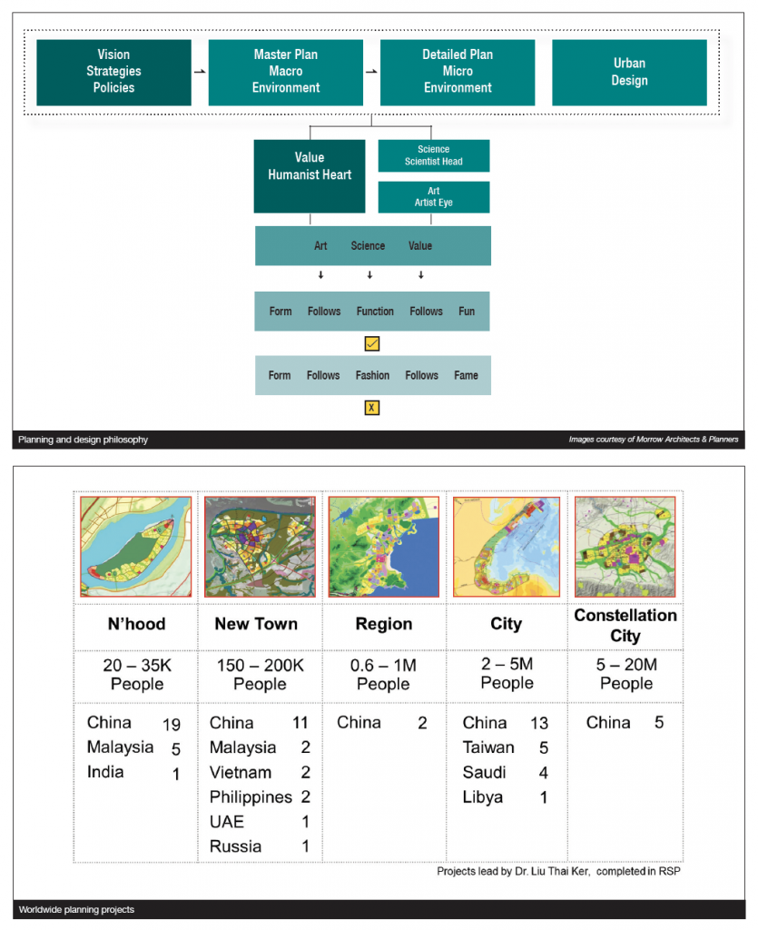
In city planning, I often say that you must have the right value. The right value is to create a liveable environment for people and a plan that makes the land sustainable. To achieve these noble objectives, you must have the scientist’s head to know what the different parts of the city are. A city is a machine for living. Our goal as an urban planner is to create a perfect machine for living. If you aim for perfection, you may achieve something that is satisfactory. If you just aim for satisfactory, then you will have a mediocre environment. So, it has to be a perfectly functioning urban machine for living. But a city is also a work of art and a receptacle for culture. Therefore, you must have the eye of an artist to decide how to blend this piece of cold, functional machine sympathetically into the land. To do so, a planner needs to be able to romance the land. These have been my guiding principles.
When I was a student of architecture, we were taught: Form follows Function. I would suggest that the word Form applies to both architecture and city planning. Function, it would seem to me, means enabling people to have a fun experience in a city or a building. We could therefore rightly say: Form follows Function follows Fun. In this case, Fun is related to Value, Function to Science, and Form to Art. However, I am concerned about the prevailing trend today, in both architecture and city planning. A number of practitioners lean more towards the practice of Form follows Fashion follows Fame. In other words, if a person plans a city or designs a building according to the prevailing fashion, he or she is more likely to enjoy instant fame. This is certainly very tempting, but not necessarily done in the best interest of the people or the land.
What do you regard as your proudest project?
I always tell people that I put my heart and soul into every project of mine. They are like my children and I love all of them.
What are some of the current challenges Singapore is facing in urban planning and how can they be overcome? Are there any differences in the approach now as compared to before?
Firstly, when I did the concept plan in 1991, I projected a population of 5.5 million by the year 2091. But by 2016, the population was already 5.5 million. Due to economic growth and the creation of jobs, Singapore needs a lot of people to fill those jobs. My wish is that we quickly try to plan a city for 10 million people. It is not excessive. When I did the 1991 Concept Plan, I made sure that there was still enough land left just in case my projection was wrong. So, I’m comfortable that we have land but the density will have to be higher in the next phase of expansion. It cannot be as low as it is today. However, if we don’t quickly plan for 10 million and we keep going on with the present rules of the game, by the time we realise that we have less and less land, then we have to further increase the density for future population growth. That’s not what I want to see. My proposal for 10 million is not to ruin the environment, but to save the environment that we are enjoying now. I think people should know that. In the process of saving the environment, my desire is to keep all the historical buildings, natural environments and landed properties. We build the new cities around them. If we do it now, we can achieve all these goals more easily. We can’t if we leave it until later. If you are in a family whereby a father is jobless and tells his son to spend money as usual, what do you do when he starts to run short of money? You will have to ration the money every day, but it’s too late so he can only give his son ten cents per day. That’s not what I want to see. But if the unemployed man rations his money earlier, then the daily allowance can be higher. Back to future planning of Singapore, if we do it now, we can have a more respectable environment or even retain the quality of environment that we are enjoying now. The second point is that I have left behind a large body of planning experience and data in planning files. When I look at some of the new planning proposals, it makes me feel that some of the current government planners don’t really know what planning principles I used in the past. My wish is for them to take a little bit more trouble to understand the past before they reinvent the wheel. It’s just like a responsible young doctor who should not ignore the past knowledge, nor should he invent a new treatment method out of the blue to cure a patient. If he ignores the past experience and invents his own method, that’s highly unacceptable because the patient may die. But a city developed according to hastily invented new methods does not die immediately. It will take 30 or 40 years for a city to deteriorate. By then, it’s too late to turn back the tide. So, I hope the new planners can pay more attention to the principles that we used in the past. The third point I want to make is that I am not against introducing new ideas, but new ideas should be introduced only after having a serious look at the long-term population projections and after having examined the accumulated past planning principles and experiences. To introduce new ideas without first examining these two points is like creating a building without foundations or footings. How will the building stand firm and last for a long time?
How can we make use of land more efficiently while planning for a more sustainable, liveable urban environment and larger population?
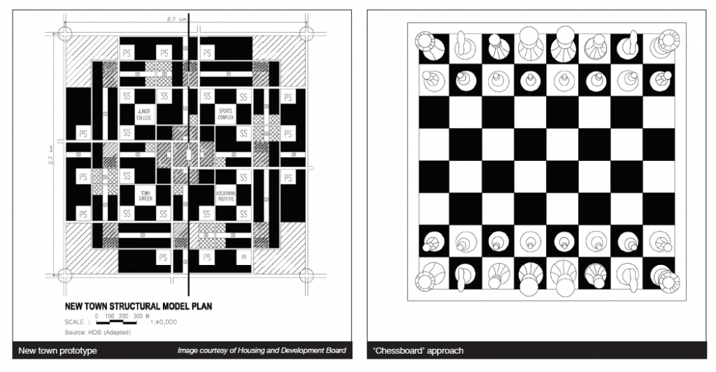
We should pay attention to human scale and take a ‘chessboard’ approach. Metaphorically speaking, HDB residential blocks were placed on the black squares of a chessboard, whereas the low-density shopping centres, schools, sports fields and even gardens and parks were placed in the alternate white squares. In this manner, we could minimise the impact of high-rise residential blocks and achieve the illusion of a lower-density environment. The overall result was having low-rise buildings interspersed among high-rise blocks, with parks and greenery punctuating the spaces between buildings.
Particularly in architecture and urban planning, you must understand what the city or a piece of architecture must serve, and what the needs of the people who use the building or the city are.
The expression of human scale can be found in most new towns, where high-and low-rise buildings are mixed. And yes, the sky is visible! Traditionally, people were most familiar and therefore comfortable with buildings of one to three storeys, or at most up to seven storeys. But we do not have the luxury of building too many of these low-density developments because in Singapore, we required high density in order to accommodate our large population on a limited amount of land. But, while residential buildings should be mainly high-density, low- and medium-rise structures can be built for non-residential uses, including kindergartens, schools, religious buildings and community centres. The high-rise residential buildings and the low-rise structures can be arranged like a western chessboard to minimise the impact of high density. These lower-rise buildings can be placed carefully and spread evenly as ‘scale indicators’ that provide relief from the dominating scale of high-rises. In addition, these lower buildings, with their varied functional demands, can have a more individualistic architectural style and expression. Therefore, if they are carefully placed at visible locations, they can provide visual variety and locational identity to our urbanscape.
How can we preserve heritage and nature areas in the process of development?
Singapore is often described as a city in a garden, with gardens in the city. Such an accolade did not come about without some serious planning and hard work. In the preparation of the 1991 Concept Plan, one of our first tasks was to identify all historical buildings and natural areas worthy of protection. Since the early 1990s, some 7,000 buildings have been gazetted for conservation and preservation. With regard to the conservation of nature, our water catchment areas immediately come to mind. Other nature conservation areas are Bukit Timah Nature Reserve, Labrador Nature Reserve, Telok Blangah Hill, Bukit Gombak Hill and Mount Faber Park, to name a few.
Further, we managed to protect most, if not all, the rivers in their natural state, except where they ran through urbanised areas and embankments became necessary. During the preparation of the 1991 Concept Plan, my colleagues and I also decided to conserve a stretch of the original beach near Changi Creek so that future generations could know and understand the appearance of Singapore’s original shores. Moreover, a number of islands are still kept in their original condition, namely St John’s Island, Kusu Island and Pulau Ubin.
Besides nature conservation, new parks and water catchment ponds were created all over the island. Neighbourhood parks, New Town parks and a number of Regional or Citywide parks were added. They are East Coast Park, Bishan Park and Sungai Seletar, to name a few. During the preparation of the 1991 Concept Plan, the land area of Bukit Timah Nature Reserve was increased to encompass the entire hill. While preparing the Bukit Batok New Town Plan, a disused stone quarry was converted into a park with a stone cliff and a deepwater pond. The scenery is so picturesque that it has been fondly nicknamed Little Guilin. We can also speak of a few beautiful gardens, such as the historical Botanic Gardens that first appeared during the British colonial times, as well as newer entries like the Chinese Garden, Japanese Garden, Gardens by the Bay, Mandai Zoo and Jurong Bird Park.
How can we cultivate a greater sense of community in the planning of spaces?
Let me share with you the HDB new town planning. A new town was subdivided into neighbourhoods of approximately 50 hectares each, with a neighbourhood centre that was complemented by all relevant amenities. But neighbourhoods were still too large a community to facilitate close and meaningful social interaction between residents, and posed challenges for nurturing emotional identification or rootedness. Therefore, I introduced a new subdivision of physical space, what is well known today as ‘precincts’. A United Kingdom survey in the 1950s showing that people could not relate to their residential area if it was larger than 5 to 6 acres sparked the decision for me to create precincts. Consultations with a sociologist further indicated that 700 to 1,000 flats would provide the suitable variety of housing types for a ‘basic community’. Translated into HDB density, this became roughly 2.5 to 3.5 hectares of land. Precincts allow for suitable human scale of land size for social interaction and emotional identification among residents. It is also large enough to accommodate different housing types to allow for socio-economic diversity and thus prevent ghetto formation. A precinct is the smallest self-contained space and community. Each precinct can be demarcated by green belts and accessible by local roads to enhance its sense of community and privacy.
In each precinct, there is also a precinct centre—usually, green space with a playground, sandpit, exercise space and sitting areas where parents can sit and talk while their children played. The precinct centre is configured, first and foremost, for safety. Its location within the precinct allows sufficient visibility to residents so that younger children can play under supervision, while older ones can enjoy unsupervised outdoor time. These spaces are designed to accommodate multiple uses by diverse age groups and, in general, to facilitate social interaction.
At ESSEC’s iMagination Week Singapore 2018, you spoke about the transformation of Singapore from the 1960s and how this city has become a model of city planning. With the theme ‘How Far Can Progress Lead Us?’, the seminar focused on creativity, imagination and transdisciplinarity. Could you elaborate on how these concepts relate to urban planning?
I learnt from a Swedish educator in arts who said that for other subjects like science, maths and geography, when you study these subjects, there is a boundary of what you must learn. But art education has no boundaries. You have to keep probing for better and better solutions. And that is a good way to help a person develop his imagination. That applies also in city planning or architectural works or artworks. But nowadays, it’s too fashionable to say that to be creative, you must have imagination, be innovative and future-ready. I’m not against those words. But I feel that it has been blown out of proportion. Although modern artists like Picasso create grotesque-looking human figures, these artists have solid basic skills. If you look at the human figure studies by Picasso and some of these famous artists, they are of very high technical standard. In other words, to have imagination, you must have solid skills. Particularly in architecture and urban planning, you must understand what the city or a piece of architecture must serve, and what the needs of the people who use the building or the city are. By knowing very clearly what these people need in a building or a city, it’s already demanding a high level of imagination. But it’s not the kind of imagination by just sitting, thinking and imagining. It is achieved through hard work, doing interviews, asking questions and collecting data. But how do you organise these random data into a coherent body of guidelines? That is an important part of imagination.
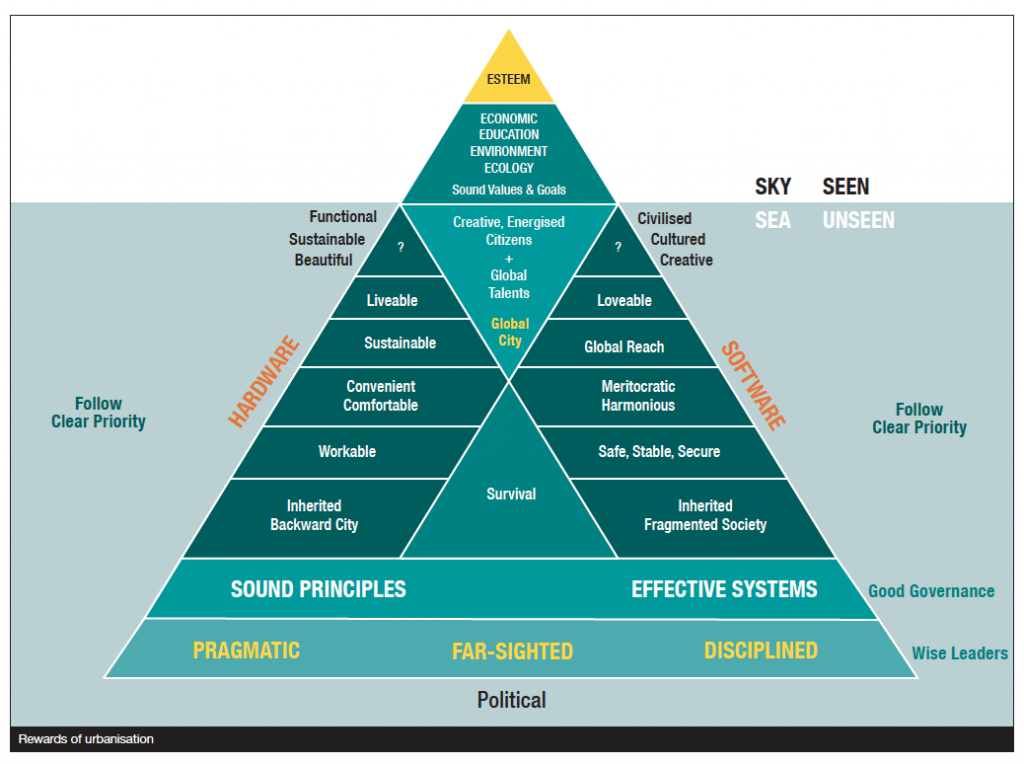
The ‘rewards of urbanisation’ diagram summarises the handsome rewards of our arduous urbanisation journey. Imagine the triangle as an iceberg. The portion below sea level cannot be easily seen, whereas the portion above sea level can be readily appreciated. The foundation of our urbanisation effort rests on having a group of pragmatic, far-sighted and disciplined political leaders. They developed our city according to sound principles obtained through hard research works, combined with an effective system of delivery.
What are your upcoming plans and what legacy would you like to leave behind?
I think I will just carry on doing the same thing. In Asia alone, if India, China and Indonesia were to develop to the level of urbanisation of the United States (USA) today, India has to build four USA. China has to build three USAs and Indonesia has to build just over one USA. That’s eight USAs. That’s a huge amount of work waiting to be carried out. I hope that I can create cities in different countries and continents, set some good examples of urbanisation for those areas and give them confidence that no matter how backward or poor they are, if they get the right urban plan, they can turn their city into a world-class environment in due course. If I can do that, I think that will be my dearest wish.